The main objective of Aral Sea Basin Management Model
This is achieved by “playing out” various versions of development of Aral Sea basin countries separately as well as the entire region for defining the possibility of economic and social development in the future, taking into account available water resources use and Aral Sea and Priaralie ecological requirements satisfaction.
ASB-MM consists of Hydrological Model,
Socio-Economic Model tries to predict what will happen to socio-economic system in compliance with the following main parameters:
- population (rural and urban);
- economy (GNP, GNP per capita, contribution of each production sector to GNP);
- water (demand of each production sector; its availability is calculated by Hydrological Model);
- agriculture (irrigated lands productivity for each technical or food crop);
- investments (amount of investments in agriculture, direct foreign investments);
- power (production and consumption);
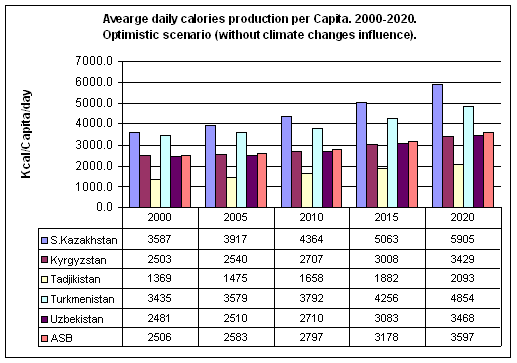
- food (production and consumption in calories, taking into account consumer basket);
- evaluation of climate change impact on water resources and agricultural production.
- to evaluate development scenarios of the region's countries in accordance with “requirements for water — available water resources”;
- to act out the versions of reservoirs management in compliance with the selected criteria and limits;
- to calculate water balances of rivers, reservoirs, and lakes.
Hydrological scheme of model does not include Kashkadarya basin rivers, the rivers in Turkmenistan (Murgab, Tejen, Atrek), inland rivers in Afghanistan, and also some local sources of Syrdarya basin (Isfara, Shakhimardan, Sokh, etc.).
The following versions of the Aral Sea basin development were calculated on socio-economic model:
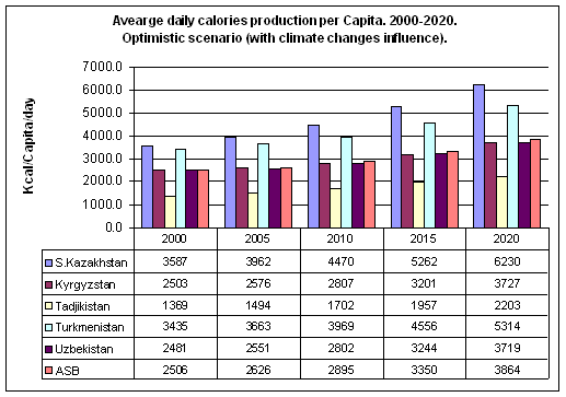
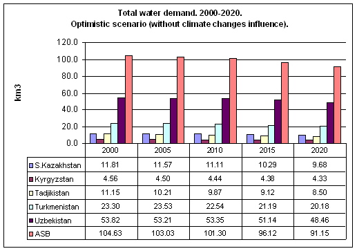
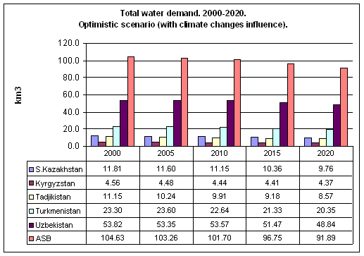
Optimistic scenario
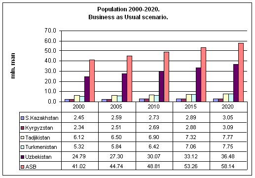
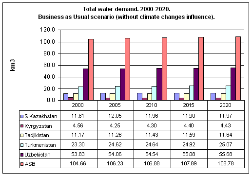
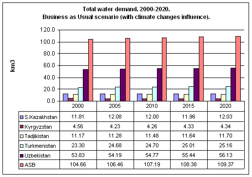
Business as usual scenario
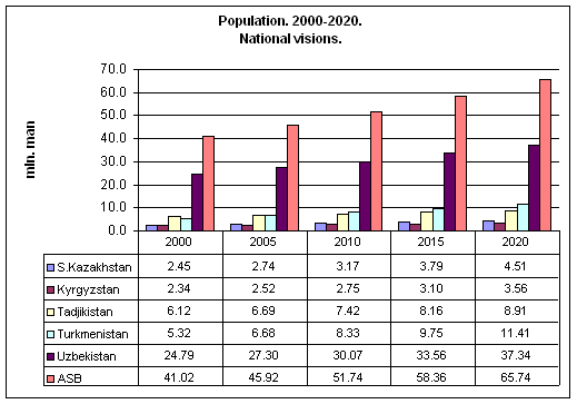
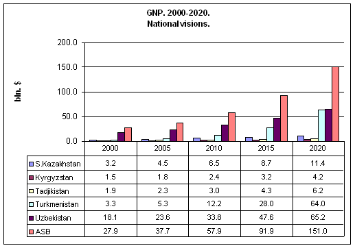
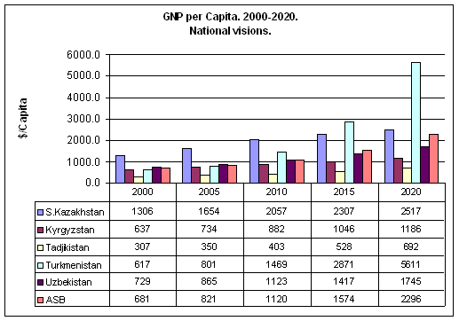
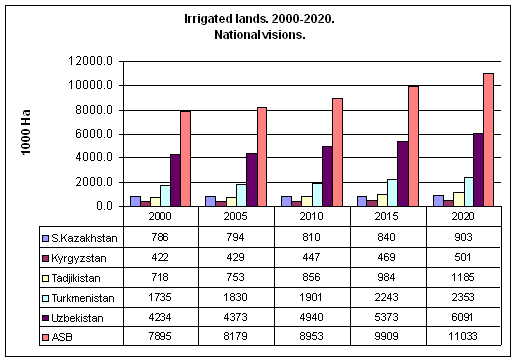
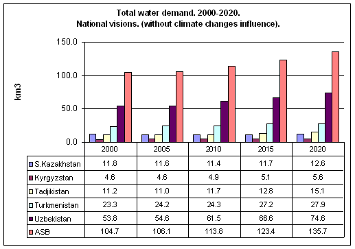
National visions
Optimistic scenario
It supposes integrated regional development, supported by all the states, including:
- Mutually beneficial transboundary water resources use on the basis of water saving and common nature conservation approaches;
- Mutually beneficial development of agricultural sector, maximally focusing on regional specialization in agricultural production;
- Maximally drawing nearer to potential water and land productivity;
- Economic growth is provided mainly owing to the development of industry and service sector.
Regional integration degree: High
Specific water use — 9.4 x 1000 m3/ha
GNP growth rate:
in the years 2000-2010 — 4-6 %
in the years 2010-2015 — 6-10 %
in the years 2015-2020 — approx. 5 %
Specific water use in drinking water supply 0.08 m3 per capita per year (220 liter/day)
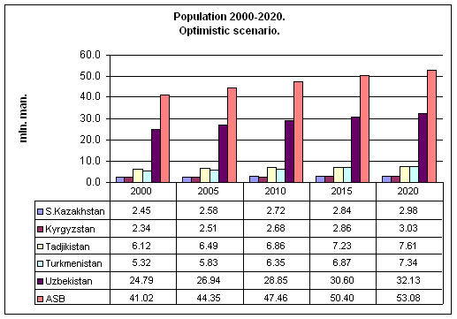
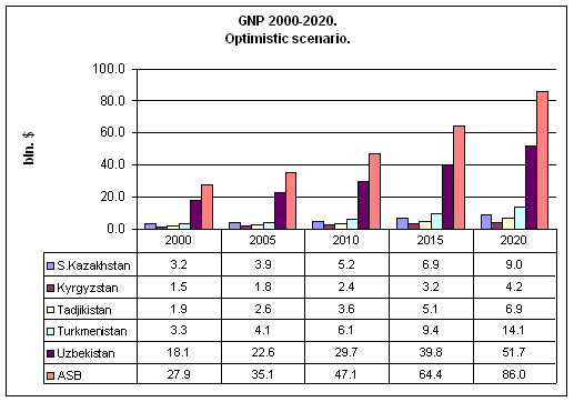
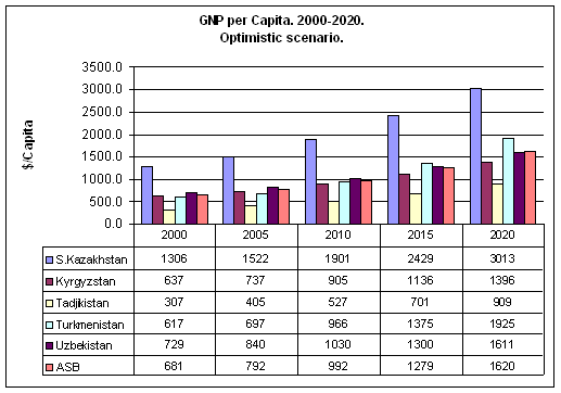
The calculated regional development dynamics are given in the graphs.

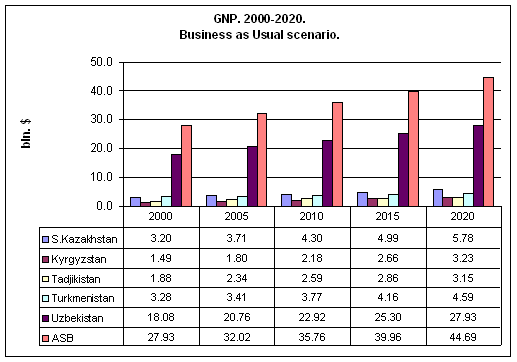
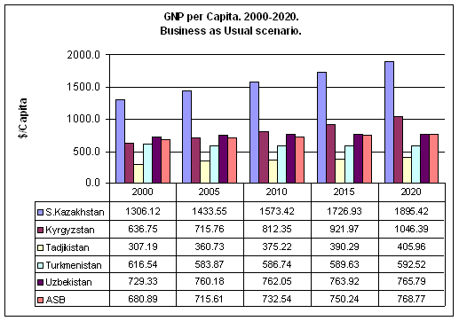
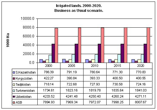
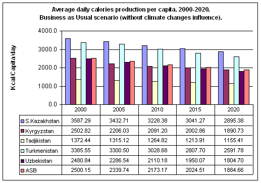
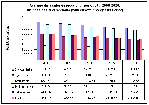
Business as usual scenario
- If the present tendency in joint transboundary water resources management remains, the aspiration for self-providing with food will prevail in development of each country;
- Transboundary water resources management integration processes develop slowly;
- Development of regional integration in agricultural production carries on weakly;
- The main efforts of the countries will be directed to the support of the existed infrastructure, while the attention to water saving is weak.
Regional integration degree: Low
Specific water use — 12 x 1000 m3/ha
GNP growth rate:
in the years 2000-2020 — < 3 %
Specific water use in drinking water supply 0.1 m3 per capita per year (280 liter/day).
The calculated regional development dynamics according to this development scenario are given in the graphs.
National visions
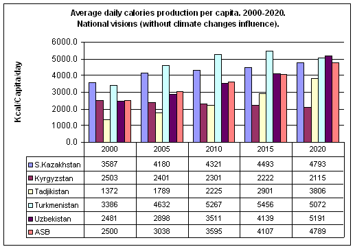
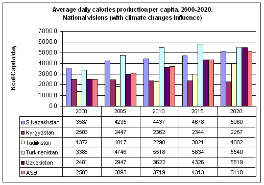
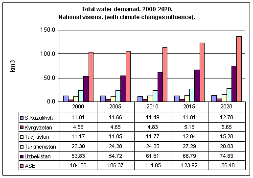
Comparison of the prospective development scenarios, taking and not taking into account climatic changes impact, shows that climatic changes impact will have a positive effect on food availability degree — about 5-7 % of growth on an average due to insignificant increase in the main crop yields, but at the same time the increase of requirements for water resources by 1-2 % a year is observed in all the scenarios.